


Unicorn Chatreuse Tours - #rigoloterie de Juin

Clément Baldzuhn
User
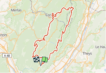

Length
101 km

Max alt
2040 m

Uphill gradient
7848 m
Km-Effort
205 km

Min alt
593 m

Downhill gradient
7848 m
Boucle
Yes
Creation date :
2024-09-21 17:02:12.62
Updated on :
2025-05-23 13:35:25.412
30h00
Difficulty : Very difficult

FREE GPS app for hiking
 SityTrail
IGN / Geographical institutes
SityTrail Plus
The world is yours!
About
Trail Trail of 101 km to be discovered at Auvergne-Rhône-Alpes, Isère, Le Sappey-en-Chartreuse. This trail is proposed by Clément Baldzuhn.
Description
Ca va piquer

Positioning
Country:
France
Region :
Auvergne-Rhône-Alpes
Department/Province :
Isère
Municipality :
Le Sappey-en-Chartreuse
Location:
Unknown
Start:(Dec)
Start:(UTM)
717982 ; 5015516 (31T) N.
Comments